Transit-oriented development is our bread and butter. MapCraft Labs makes it easy to:
- Ask high impact questions. You define the specific analyses that are relevant to your project. MapCraft Labs can be used to analyze:
- Equitable TOD,
- Redevelopment feasibility,
- Displacement impacts,
- Transit investment alternatives,
- Value capture funding capacity, and more.
- Get context-specific answers. MapCraft runs your analysis on every parcel (or TAZ, census tract, neighborhood) and maps the results. Why use typologies when you see actual results for every place?
- Make better decisions, faster. With MapCraft, it’s easy to create, test, and visualize new policy scenarios in real-time. Analysis should support the decision making process, not slow it down.
- Available at whatever scale you need. MapCraft Labs works at any scale, from parcels and transit stations to metro areas and regional networks.

View our affordable housing demo
See how affordable housing requirements impact development feasibility in our West Coast demo.
How is MapCraft different?
Many questions require analyses of how real estate feasibility varies across space—whether a study area, corridor, city, or metro area. Traditionally, planners must compromise: either use industry-leading financial modeling techniques to examine a few prototypical sites, or analyze the entire study area using simplified approaches or proxy measures. We built MapCraft to resolve this tradeoff. With MapCraft Labs, you get the best of both worlds: high-quality analysis at all scales.
Large datasets? Not a problem. We used MapCraft to analyze more 2 million parcels in Los Angeles County.
Need to model the impact of different policy options or changing market conditions? MapCraft makes it easy. MapCraft supports detailed financial models that are sensitive to all the factors that influence developer decision making. With just a few clicks, you can create new scenarios to test how regional changes or geographically targeted measures would impact development feasibility.

View our Seattle-area transit demo
Explore how transit investments could change development outcomes in the Puget Sound area.

Targeting TOD investments in Salt Lake City
With more than 60 light rail and commuter rail stations in its network, the Utah Transit Authority (UTA) needed help prioritizing the station locations where its TOD resources would have the greatest effect.
The project team used MapCraft Labs to build a tool that identifies station locations that exhibit high TOD readiness. The TOD readiness index incorporates factors related to market development potential, supportive zoning, existing density, demographics, affordable housing, and multimodal accessibility.
Stakeholders used the Lab to vary the weights of various attributes to see how the resulting composite score might reprioritize station areas within UTA’s TOD investment portfolio.
The TOD Readiness Lab makes it easy to see how changing the importance of one factor can affect investment priorities. Eventually UTA plans to share the information publicly on its website, with regular updates to reflect changing market conditions.


Reimagining station area planning in Seattle

In 2016, Seattle-area voters approved a 60-mile transit system expansion, including new light rail routes connecting the West Seattle and Ballard neighborhoods to downtown Seattle. Sound Transit set out to incorporate station planning concerns—including equitable TOD, new job capacity, and redevelopment potential—early in the planning process for these two projects. To help prioritize routes and station alternatives, the project team used MapCraft Labs to analyze TOD potential in six station areas.
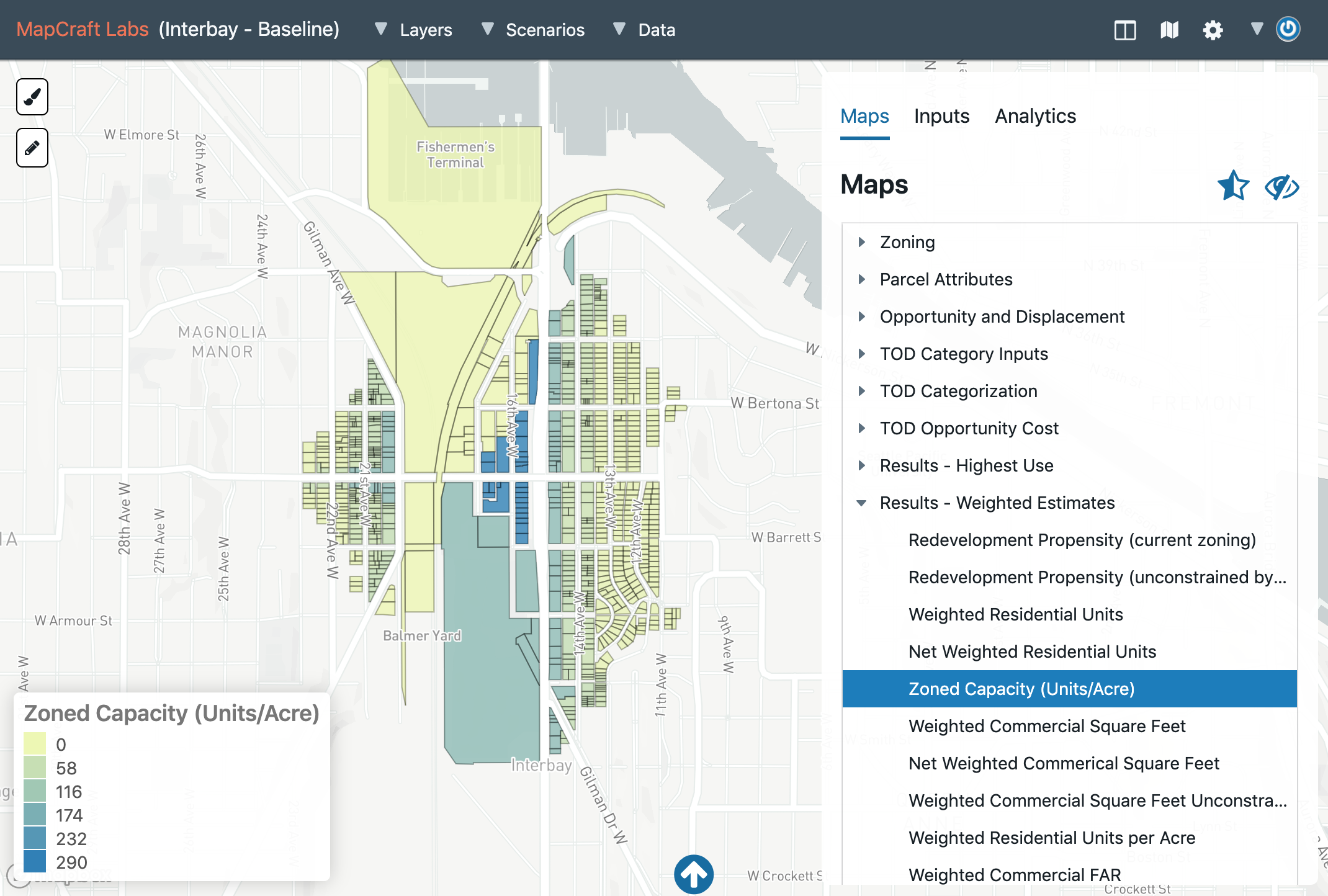
The Sound Transit Lab uses a variety of data to categorize TOD opportunities. For example, the Lab identifies sites suitable for agency-led TOD as well as possible targets for affordable housing preservation. To do so, the Lab calculates the financial feasibility of more than one hundred building prototypes—including single-family, multifamily, mixed-use, industrial, office, and hotel—on each parcel in the station areas. Users can modify assumptions about market conditions and zoning to see how development outcomes might change.
Sound Transit is currently preparing an Environmental Impact Statement for the project. They continue to use MapCraft Labs to analyze how development, displacement, and TOD outcomes would differ between project alternatives.

Analyzing regional land use scenarios in Las Vegas
Greater Las Vegas is the largest region in the country without a long-range transit plan. Having recently completed a long-range land use plan, the Regional Transportation Commission of Southern Nevada (RTC) set out to prepare a comprehensive regional transit plan that could leverage transportation investments to support the region’s TOD aspirations.
Using MapCraft Labs, the project team was able to apply industry-leading real estate financial modeling techniques to every parcel in the region. This allows RTC to model how transit investments and zoning changes could affect the the distribution of households and jobs.
The web app interface makes it simple to create new scenarios reflecting different transit investment options, land use regulations, regional growth scenarios, and market conditions. The Lab takes only a few minutes to calculate scenario results for all 800,000 parcels in the region.
The MapCraft outputs are helping RTC make informed decisions about how future transit investments can best serve the region’s residents. RTC expects to release the final plan in early 2020.


Promoting equitable TOD
in Portland
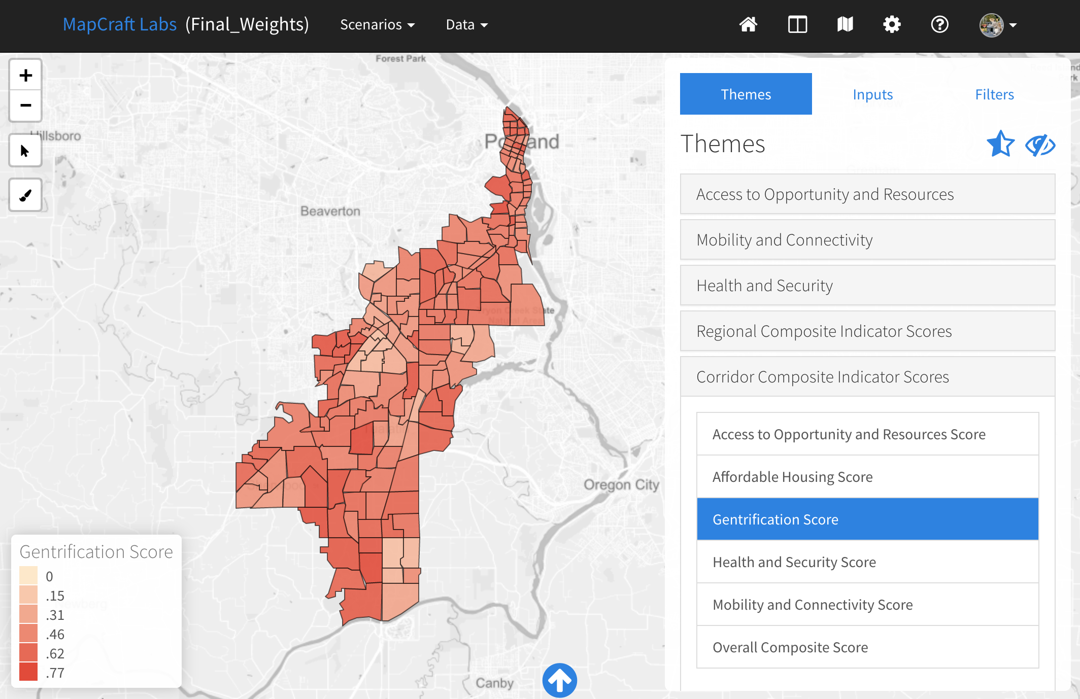
The 12-mile Southwest Corridor light rail extension represents a major investment in transportation reliability and safety in the Portland region. Oregon Metro, the City of Portland, and the City of Tigard want to ensure that the corridor remains affordable to current residents and businesses. Metro has relied on MapCraft Labs to help develop a corridor-specific equitable development strategy (SWEDS) to promote housing affordability and economic development.
An important part of SWEDS is developing a robust system for comparing and monitoring key equitable development indicators. The project team used MapCraft Labs to analyze and visualize data on more than 50 individual metrics for 180 subareas along the corridor. The SWEDS Lab was used to develop the methodology for calculating subarea indexes for gentrification, affordable housing, access to opportunity, mobility, and health and security. The resulting SWEDS Index tool allows Oregon Metro to geographically target equitable development tools that are appropriate for the diverse conditions along the corridor.
The final SWEDS Action Plan is nearing completion and will be published in 2019. Moving forward, Metro plans to use the Lab to inform a variety of strategy decisions, from where to invest in new development to how to best mitigate displacement.